The idea of navigating the Brazos River via steamboats began in the1800's. As early as 1832, the lower Brazos River was being used for commerce and this commerce increased in importantance until about 1858. During this time, the high-water navigation extended up to Washington, and the low-water navigation extended up to Columbia. It was claimed that boats could navigate up to Washington for eight months of the years were it not for the three bridges that had been constructed between Columbia and Washington. Around 1858, an inland canal was constructed connecting the Brazos River to Galveston Bay. This canal was intended to help increase commerce along the river, but the City of Houston was extending its influence via railroad into the area above Columbia and had essentially drawn away all of the trade.
Supporters of river trade claimed that the three bridges across the Brazos River had been built illegally and that reopening navigation of the Brazos River up to Washington was necessary to provide competition to the railroads and their high freight rates. The more ardent apparently wanted the river trade to extend all the way to Waco. Citizens of Washington County petitioned the State legislature to ask the Federal government to conduct a survey for this purpose. The first survey for this purpose was authorized by act of Congress approved June 23, 1874 and was conducted by Assistant Engineer R. B. Talfor, commencing in July, 1874. Talfor's survey concluded that, while low-water navigation above Columbia was feasible by incorporating draws into the bridges and removing river snags, it would cost more than it was worth. Talfor also concluded that from Washington to Waco, except at extreme high water, navigation would only be possible by a system of locks and dams.
The idea to make the Brazos River navigable during low-water continued over the years with surveys periodically being requested by the U. S. Congress. In 1891, Maj. Charles J. Allen examined the Brazos River from its mouth to Waco in response to an act of Congress approved September 19, 1890. He found that commerce on the river above Columbia consisted of one steamboat running from Galveston (via the West Galveston Bay-Brazos Canal) to Columbia, and further up the river to Port Bolivar water stage permitting. Allen examined the river from its mouth to Port Bolivar and found numerous impediments to low-water navigation between Columbia and Port Bolivar. He also concluded that a series of locks and dams would be necessary, at least between Waco and Port Bolivar, "the cost of which would be out of all proportion to the present commerce of the river." He could find no good reason why the Federal government should undertake any improvements to the Brazos River.
In 1892, Maj. Charles J. Allen examined the Brazos River once again, this time from its mouth to Richmond in response to an act of Congress approved July 13, 1892. His opinion had changed somewhat since the previous year, but he was only examining the river below Richmond. He found that commerce had increased somewhat and concluded that improvements would be worthwhile as long as the cost, which would need to be determined by a full survey, did not outweigh the benefits to commerce.
Eventually, the idea of making the Brazos navigable up to Waco won out. In 1905, a plan was developed and construction of eight locks and dams was authorized. Construction began on three locks but floods in 1913 destroyed much of the work. Work was then halted during World War I. Finally, the flood of 1921 changed the course of the river in places, leaving Lock and Dam #8 on dry ground. The project was completely abandoned by 1922.
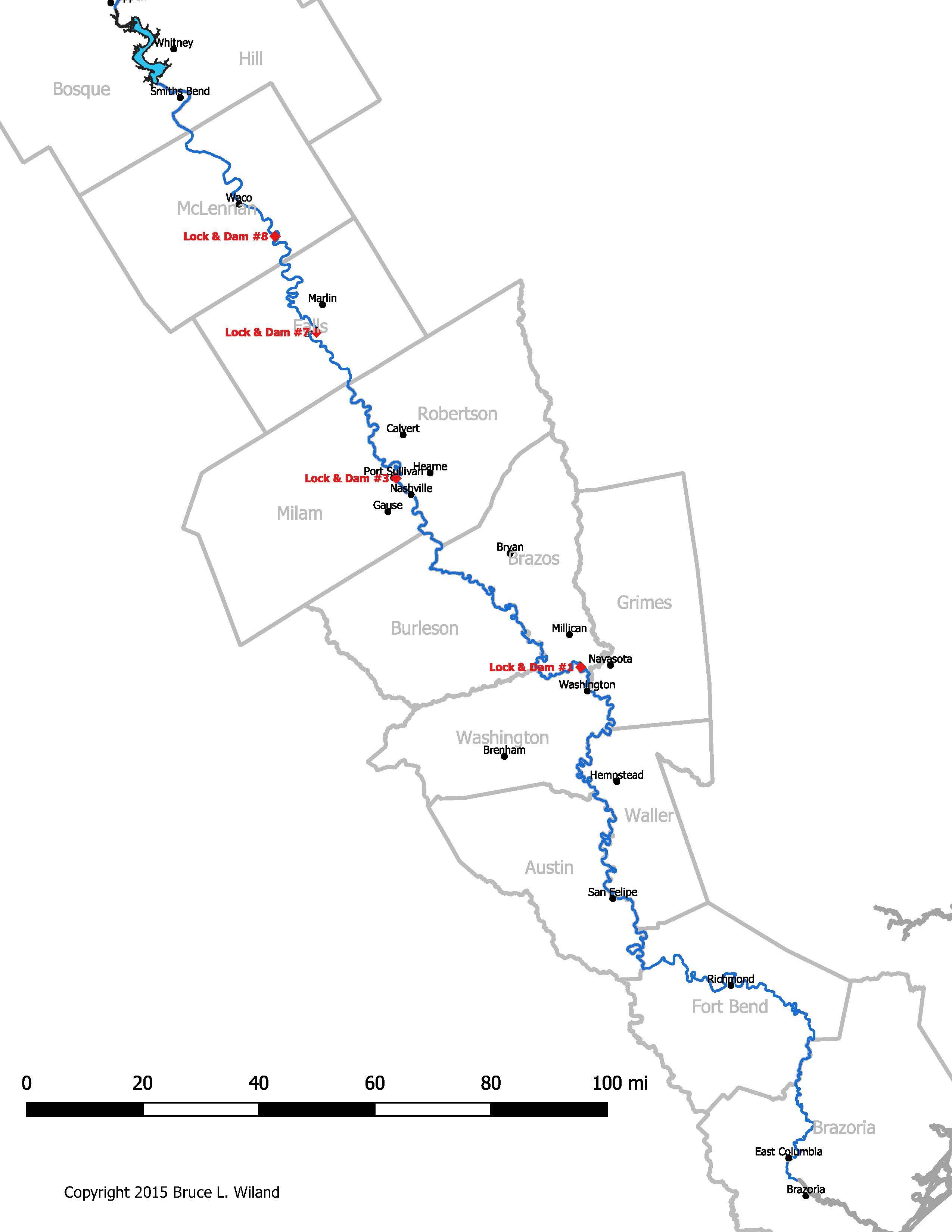
Map of Lock Locations
The locations of Lock and Dam #1, #3, #7, and #8 are shown on the map below. Click on it to enlarge.
Google Map Links
The links below show the current state and location of the three locks that were partially constructed. The links will open in a separate tab. Zoom out to see their relation to the rest of the river.
Remnants of Lock #1 below Hidalgo Falls (zoom out to see Hidalgo Falls north of Lock #1)
Remnants of Lock #3 at Port Sullivan
Remnants of Lock #8 below Waco (this lock is now on dry land; zoom out to see the current location of the river to the east and north)
Photos of Lock and Dam Construction
Click your back button to return to this page after viewing.
Lock and Dam #1 (January 11, 1917)
Lock and Dam #3 (May 6, 1918)
Lock and Dam #8 (June 15, 1917)
see more photos of Lock and Dam #1
see more photos of Lock and Dam #3
see more photos of Lock and Dam #8
City of Waco Video on Brazos River Locks and Dams
References
Report of the Chief of Engineers, Survey of Brazos River Below Waco, by R. B. Talfor, 1874 from 44th Congress, 1st Session, House Ex. Doc. No. 1, Part 2; Congressional Serial Set 1675 (3 MB)
Report of the Chief of Engineers, Preliminary Examination of Brazos River from Mouth to Waco, by Maj. Charles J. Allen, 1891 from 52nd Congress, 1st Session, House Ex. Doc. No. 1, part 2, vol. II; Congressional Serial Set 3019 pp. 1555-1562 (2 MB)
Report of the Chief of Engineers, Preliminary Examination of Brazos River from Mouth to Richmond, by Maj. Charles J. Allen, 1892 from 53rd Congress, 2nd Session, House Ex. Doc. No. 1, vol. 5; Congressional Serial Set 3201, pp. 1893-1899 (1 MB)
Report of the Chief of Engineers, Preliminary Examination of Brazos River from Waco to Richmond, by Maj. A. M. Miller, 1895 from 54th Congress, 1st Session, House Doc. No. 1; Congressional Serial Set 3373, pp. 1833-1837 (<1 MB)
Report of the Chief of Engineers, Letter from Waco Commerical Club, 1897 from 55th Congress, 2nd Session, House Doc. No. 92, Vol. 2, Part 2, App. O of App. T; Congressional Serial Set 3632 (<1 MB)
Report of the Chief of Engineers, Hearing by the Brazos River Board, 1897 from 55th Congress, 2nd Session, House Doc. No. 92, Vol. 2, Part 2, App. Q of App. T; Congressional Serial Set 3632 (<1 MB)
Report of the Chief of Engineers, Examination and Survey of Brazos River, by Capt. C. S. Richie, 1901 from 57th Congress, 1st Session, House Doc. No. 2; Congressional Serial Set 4281, pp. 1974-2018 (3 MB)
Survey of Brazos River, Old Washington to Waco, 1909 from 62nd Congress, 1st Session, House Doc. No. 95; Congressional Serial Set 6116 (<1 MB)
Report of the Chief of Engineers, Reexamination of Brazos River, 1919 from 66th Congress, 1st Session, House Doc. No. 298; Congressional Serial Set 7643 (3 MB)
Report of the Chief of Engineers, Galveston District, Brazos River, Old Washington to Waco, 1920 from 66th Congress, 3rd Session, House Doc. No. 840; Congressional Serial Set 7810 (<1 MB)
Related Links
Research on the "Falls of the Brazos by Bruce Wiland
Port Sullivan’s history was not as a fort by John Brockman
History of Port Sullivan, Milam County, Texas by Leonard Kubiak
Port Sullivan, Texas by John Martin Brockman, Texas State Historical Association Handbook of Texas
Brazos Geography by the Blinn Geographic Society
Brazos River Lock and Dam by John Rich
Waco and the Brazos River curated by Baylor University Institute for Oral History & The Texas Collection
A Defiant River, a Technocrocratic Ideal: Big Dams and Even Bigger Hopes along the Brazos River, 1929 - 1958 by Kenna Lang Archer
Hidalgo Falls, Brazos River by Steve Daniel
Damming the River of the Arms of God: The People of the Brazos and their Unruly River by Kenna Renee Archer